Written By TECH Staff
How modern technology helps you successfully reach the Larkya La Pass on the Manaslu Circuit Trek
Modern technology enhances safety on Larkya La Pass by improving navigation, weather forecasting, communication, and health monitoring, reducing uncertainty while preserving the trek’s extreme high-altitude challenges.
Edited By: TECH Staff | Published By: TECH Staff | Published: Mar 18, 2026, 05:14 PM (IST)
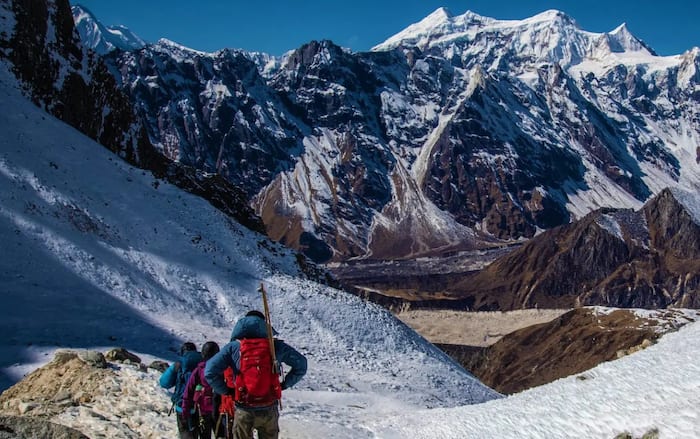
![]() Trekkers crossing snow-covered Larkya La Pass at sunrise with Himalayan peaks glowing under extreme high-altitude conditions.
Trekkers crossing snow-covered Larkya La Pass at sunrise with Himalayan peaks glowing under extreme high-altitude conditions.
The Himalayas remain unforgiving, but the tools you carry have evolved — dramatically improving your chances of safely crossing Larkya La.
The Pass That Earns Its Reputation
Larky La Pass is one of the highest points on the Manaslu Circuit Trek at five thousand one hundred sixty metre. It also passes around Mount Manaslu, which is the eighth highest mountain in the world and located in northwest Nepal. Early start time (often two through three a.m.) required to reach summit prior to potential high winds/dangerous conditions due the exposed ridge.
There are usually temperatures lower than fifteen degrees Celsius (-15ºC) and potentially zero visibility due to the trails being sometimes unmarked and/or covered by a substantial quantity of snow, with some trails completely disappearing underneath a minimum amount of snowfall during Winter and Early Spring months.
Finding success has been determined by proper physical preparation; having an experienced guide from the vicinity of the trek, plus having proper weather conditions. While these three components have remained unchanged since the establishment of this trek, modern technologies have completely changed the amount and timeliness of information now provided prior to making your trip.
Modern technology does not eliminate the difficulty of crossing Larky La Pass; however it doesreduce the uncertainty associated with this now traditional trek around Mount Manaslu.
Navigation Technology: Tracking the Invisible Trail
Cellular coverage vanishes well before high altitude — by Samdo or Dharamsala (the last acclimatization stops), there is no signal at all.
Live-data-dependent apps become useless.
Here, offline-first apps shine like Gaia GPS; Use this app to download a detailed contour map of the entire trekking area of Kathmandu as well as showing terrain overlay and locate your GPS position while not having any internet service.
The Maps.me app provides similar features to Gaia GPS but has a slightly easier user experience, making it a good backup source as well.
Wikiloc tracks a significant advantage over the previous apps by offering up-to-date GPS tracks uploaded by previous trekkers on the Manaslu Trail. When the snow obscures the trail, it is much safer to follow a verified track that was uploaded within the last month, which should have points to locate teahouses, river crossings, and technical sections.
Finally, out in extreme cold weather the technical specifications of your electronic navigational devices will significantly impact on how well they operate. A standard lithium-ion battery can lose up to 40% of its total available battery power below freezing temperatures. Make sure you carry your GPS device (smartphone or watch) inside your Moses sack when you aren’t using them; furthermore, you should have a cold rated lithium-polymer battery to ensure you will have GPS navigation capability at 3:00 a.m. when you are at the summit.
Weather Technology: Altitude-Specific Forecasts
Valley forecasts change considerably by 5,160 meters. Storms can also build up very quickly at altitude and the wind can quickly increase at ridges. No relationship can usually be found between a teahouse report from the previous evening and the conditions at dawn.
For high altitude trekking we recommend the following three reliable platforms:
1. Mountain-Forecast.com produces elevations-specific summit forecasts using 5,000 meter bands — this is the website of choice for the majority of outfitters and expeditions on Manaslu.
2. Windy is an online resource providing animated overlays of both ECMWF and GFS model data, allowing you to visualize systems moving towards you hours in advance. It also allows you to cache wind & precipitation forecasts for 48 hours on your device before you lose access to WiFi. This is useful for established Himalayan users so that they can use this device method to identify stable periods, the same methodology employed to use for 8,000 metre peaks.
3. Yr.no has received multiple recommendations from Nepali trekking guides for its accurate weather forecasts for Mountaineering in Nepal and is therefore easy to set up for free.
Review each of the three models the day prior to the attempt on the Larkya La. A majority agreement on all three will be confirmation to proceed; any dissent would indicate a delay of at least one day.
There is no cellular coverage between Samagaon and Bimthang (the section of the Larkya La crossing). If there is an emergency, a smartphone will not work. Satellite communication has made it possible to transmit messages and coordinates via satellite (as opposed to cellular) for emergencies in some of the most remote parts of Nepal.
One option for doing this is through the Garmin inReach Mini 2, which uses the Iridium satellite system (composed of a network of 66 polar-orbit satellites) for true global coverage. It offers two-way text messaging, SOS alerting (to GEOS International) with GPS coordinates accurate to within one metre, and Bluetooth compatibility with smartphones (to make text messaging much easier). Battery life is ~14 days on track mode — plenty of time for doing the entire circuit. Also, it provides on-demand weather information via satellite from Dharamsala (when no other source is open) — which has prevented dangerous crossings.
A less expensive, smaller model is the SPOT Gen4, which has one-way messaging capability (and SOS alert) but does not allow for two-way return messaging. This has the potential for serious implications in an emergency, if rescuers require clarification about how to respond. On the isolated side of Manaslu, there should be careful consideration before purchasing a SPOT Gen4.
Wearable Technology: Objective Altitude Monitoring
Altitude can be unpredictable and unique to individual experiences. Oxygen saturation levels fall, heart rates increase, and acclimatization (increased number of red blood cells produced; modified respiratory rate) can take days to occur. AMS can occur very quickly in otherwise healthy, highly motivated trekkers that traverse altitudes without concern for symptoms suggesting possible altitude related problems.
Wearables provide objective data when self-assessment falters
Wrist-worn Fingertip Pulse Oximeters give you immediate and appropriate SpO₂ readings and a resting heart rate. High-altitude trekkers worldwide consider the Gold Standard for SpO₂ monitoring to be the Masimo MightySat because it provides you with the best combination of clinical accuracy, speed of reading, and stability compared to wrist-based devices. Consequently, several guides on Manaslu carry the MightySat so they can monitor climbers’ SpO₂ & make decisions based on it. If SpO₂ remains below 80% for an extended period, it is a strong indicator that decision-makers must descend rapidly.
Garmin Fenix 7 and Apple Watch Ultra 2 are examples of smartwatches that provide wrist-based SpO₂ readings with the purpose of monitoring trends and providing alerts throughout the day. They are useful for identifying trends (i.e., steady declines) which can be missed by single spot-checking, but should only be viewed as supplemental forms of SpO₂ monitoring.
Multi-function watches like Garmin Fenix 7 and Suunto Vertical combine navigation functions with biometric monitoring. In addition to SpO₂ monitoring, multi-function watches include barometric altimeters to accurately measure elevation (superior to GPS), storm alerts based on local pressure changes and provide battery life estimates for multi-day expeditions. Regardless of how quickly weather is visually apparent, storm alerts can influence decisions to proceed with climbing Larkya La.
Power Management: The Cold Battery Challenge
Batteries are the power source for all devices. They tend to degrade rapidly when exposed to colder temperatures. The availability of charge sources diminishes above the village of Dharapani (not available at all above the village of Samdo). Therefore, the rated capacity and estimated usage based on time can be misleading. For example, a 14-day battery operating at high altitudes may only last for 8 days, and a 20,000 mAh battery bank will provide only approximately 11,000 mAh of usable power at high altitudes.
What Technology Delivers on Larkya La
Larkya La at sunrise — with the majestic Himalchuli and Cheo Himal visible in the south, and the Bimthang descent just ahead — can rank #1 amongst all the world’s incredible trekking experiences. To create this moment, we have all the previous days of up to 4,000m in altitude gain, remote teahouses and remote villages.
Technology doesn’t provide the experience itself; rather, it’s a way to lessen our reliance on luck. Offline maps can show the trail line on the ground when it is covered with snow. Accurate forecasts help us identify realistic weather windows. Satellite communications can call for assistance when no phone signal is available. Data taken on a regular basis replaces bravado-based decision-making for acclimatization with informed acclimatization decisions.
Guided trekking is required for the Manaslu Restricted Area in Nepal. This regulation is wise, and no app can replicate the value of local experience. The ideal system is to combine the expertise of a seasoned local guide with modern technologies that help minimize risk and maximize safety margins.
Larkya La is still a challenging trek; however, it is considerably easier to make evidenced-based decisions based on the knowledge of the trekking experience. Much of the battle of being in the mountains is based on the knowledge that has been gained from other trekkers.
In order to trek the Manaslu Circuit you must have both a Restricted Area Permit and a Manaslu Conservation Area Permit. Most agencies now handle applications online — please ensure that you confirm this when making your booking in order to avoid any delays on the day of arrival.
Add Techlusive as a Preferred Source
Use Disclaimer: This article is from the Brand Desk. User discretion is advised.